search
Italy region map
Map of Italy and regions. Italy region map (Southern Europe - Europe) to print. Italy region map (Southern Europe - Europe) to download. Italy (officially, the Italian Republic) comprises of 15 regions (regioni, singular - regione) and 5 autonomous regions (regioni autonome, singular - regione autonoma) as its shown in Italy region map. The regions are: Abruzzo, Basilicata, Calabria, Campania, Emilia-Romagna, Lazio (Latium), Liguria, Lombardia, Marche, Molise, Piemonte (Piedmont), Puglia (Apulia), Toscana (Tuscany), Umbria, and Veneto. The autonomous regions are: Friuli Venezia Giulia; Sardegna (Sardinia); Sicilia (Sicily); Trentino-Alto Adige (Trentino-South Tyrol) or Trentino-Suedtirol (German); Valle d'Aosta (Aosta Valley) or Vallee d'Aoste (French).
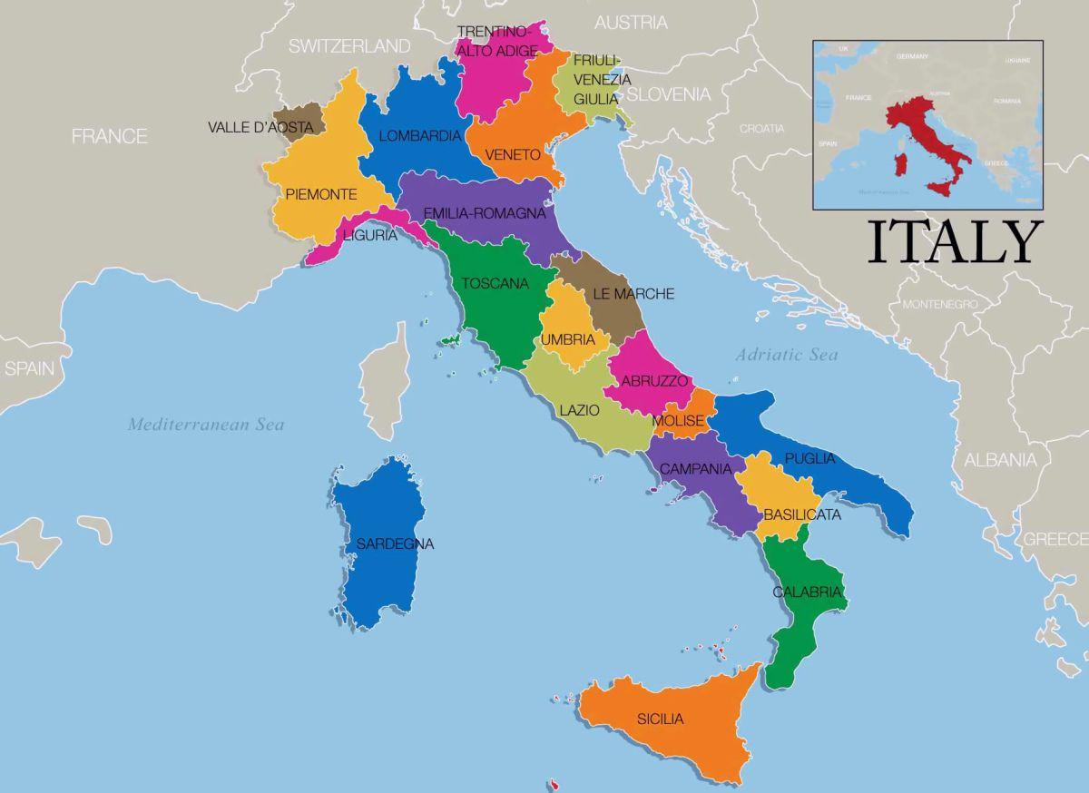
Italy is divided into 20 administrative regions, which correspond generally with historical traditional regions, though not always with exactly the same boundaries as its mentioned in Italy region map. A better-known and more general way of dividing Italy is into four parts: the north, the centre, the south, and the islands. The north includes such traditional regions as Piedmont, which is characterized by some French influence and was the seat of united Italy former royal dynasty; Liguria, extending southward around the Gulf of Genoa; Lombardy, which has long been noted for its productive agriculture and vigorously independent city communes and now for its industrial output; and Veneto, once the territory of the far-flung Venetian empire, reaching from Brescia to Trieste at its greatest extent.
The centre of Italy includes the region of Emilia-Romagna, with its prosperous farms; the Marche; Tuscany and Umbria, celebrated for their vestiges of Etruscan civilization and Renaissance traditions of art and culture; Latium (Lazio), which contains the Campagna, whose beautiful hills encircle the “Eternal City” of Rome; and the Abruzzo and Molise, regions of the highest central Apennines, which used to support a wild and remote people as you can see in Italy region map. The south, or Mezzogiorno, includes Naples and its surrounding fertile Campania; the region of Puglia, with its great plain crossed by oleander-bordered roads leading to the low Murge Salentine hills and the heel of Italy; and the poorer regions of Basilicata and Calabria. On the islands of Sicily and Sardinia are people who take pride in holding themselves apart from the inhabitants of mainland Italy.
In 2017, the largest among the 20 administrative regions of Italy was Sicily, which at same time was also the biggest island in the country. On the other hand, the smallest region of Belpaese was Aosta Valley, located in the north on the border with Switzerland and France as its shown in Italy region map. The symbol of Sicily, Mount Etna, is one of the most active volcanos on the planet. But Etna is not the only phenomena of this kind on the territory. In fact, there are other five volcanoes in the region. Overall, there were nine active volcanoes in Italy in 2019: six in Sicily, two in Campania (Mount Vesuvius and Phlegraean Fields) and one in the area of Colli Albani in Lazio.
The Italian state is divided into regions. Each region is subdivided into a handful of provinces as its mentioned in Italy region map. The smallest administrative unit is a comune, which has a mayor and a local authority, but may contain just a few hundred residents. Each Italian region has its own character and its own regional cuisine, and if you are planning a longer holiday it is worth considering getting to know a region in depth. Most have regional airports which are served by international flights.